
IMD Issues Heavy Rain Alert for 16 States as Multiple Weather Systems Turn Active Across India
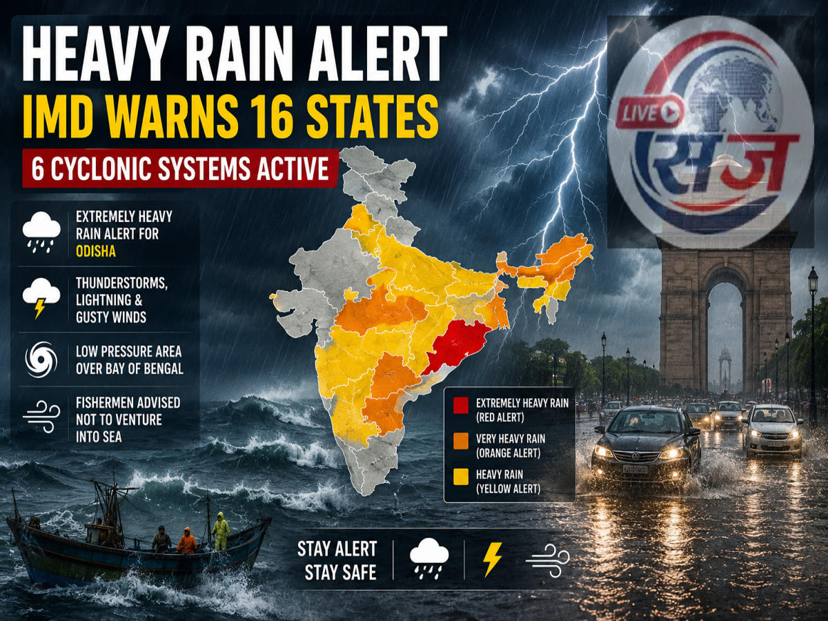
Low-pressure area and several cyclonic circulations to intensify rainfall in eastern and northeastern India, while Delhi, Uttar Pradesh and nearby regions are expected to continue facing hot and humid weather
The India Meteorological Department (IMD) has released its latest weather bulletin, warning of widespread rainfall activity across several parts of the country. According to the forecast, a low-pressure area over the Bay of Bengal along with multiple active cyclonic circulations is expected to trigger heavy to extremely heavy rainfall in many states over the next 24 to 48 hours.
Odisha has been placed under a red alert for extremely heavy rainfall, while several other states have been advised to prepare for intense showers, thunderstorms, lightning and gusty winds. In contrast, Delhi, Haryana, Punjab and large parts of Uttar Pradesh are likely to continue experiencing hot and humid conditions with limited rainfall.
Low-Pressure Area Strengthens Over the Bay of Bengal
Meteorologists said that a well-marked low-pressure area remains active over the northwest Bay of Bengal near the coasts of northern Odisha and West Bengal. The associated cyclonic circulation extends into the middle levels of the atmosphere and is expected to strengthen further while moving northwest over the next several hours.
This system is likely to enhance monsoon activity across eastern and central India, increasing the chances of heavy rainfall in nearby regions.
Multiple Cyclonic Circulations Influencing Weather
Apart from the low-pressure area, several cyclonic circulations are currently affecting weather conditions across the country.
Key weather systems include:
A western disturbance active over northern Pakistan and adjoining Jammu region.
A cyclonic circulation over northwestern Uttar Pradesh.
Another circulation over eastern Uttar Pradesh extending into Bihar.
An upper-air cyclonic circulation over eastern Uttar Pradesh.
A cyclonic system over northern Bihar.
Additional circulations over eastern Assam and northern Gujarat adjoining southwest Rajasthan.
The monsoon trough currently stretches from Punjab through Uttarakhand, Uttar Pradesh, Bihar and West Bengal before reaching the Bay of Bengal. Meanwhile, another western disturbance is expected to influence northwest India from July 19, which could alter rainfall patterns in the coming days.
States Under Heavy Rainfall Alert
The IMD has issued rainfall warnings based on the expected intensity of precipitation.
Extremely Heavy Rainfall (Red Alert)
Odisha
Very Heavy Rainfall
Gangetic West Bengal
Chhattisgarh
Arunachal Pradesh
Heavy Rainfall Expected
Heavy rain accompanied by thunderstorms is likely over:
Bihar
Jharkhand
Uttarakhand
Assam
Meghalaya
Sub-Himalayan West Bengal
Sikkim
Coastal Andhra Pradesh
Nagaland
Manipur
Mizoram
Tripura
Residents in these areas are advised to remain alert for possible waterlogging, localized flooding and travel disruptions.
Thunderstorms, Lightning and Strong Winds Forecast
The weather department has also warned of thunderstorms, lightning and gusty winds across several states.
Wind speeds of 40–50 km/h, with higher gusts in isolated places, are likely over:
Andaman and Nicobar Islands
Andhra Pradesh
Eastern Uttar Pradesh
Gangetic West Bengal
Jammu, Kashmir and Ladakh
Jharkhand
Madhya Pradesh
Vidarbha
Meanwhile, parts of Bihar, Karnataka and Telangana may experience winds reaching 30–40 km/h along with lightning activity.
Frequent lightning is also expected across:
Arunachal Pradesh
Assam
Meghalaya
Chhattisgarh
Maharashtra (including Marathwada)
Nagaland
Manipur
Mizoram
Tripura
Uttarakhand
Sub-Himalayan West Bengal
Sikkim
Delhi, Uttar Pradesh and Haryana to Continue Facing Humidity
Despite widespread rainfall elsewhere, residents of Delhi-NCR, Haryana, Punjab and large parts of Uttar Pradesh are unlikely to receive significant relief from the weather immediately.
According to the forecast, these regions are expected to witness:
Hot and humid daytime conditions
High moisture levels
Discomfort due to limited rainfall
Warm nights in several districts
Similar humid conditions may also affect parts of Telangana and coastal Karnataka, while isolated areas of Andhra Pradesh and Tamil Nadu could continue experiencing heat stress.
Fishermen Advised Not to Venture Into the Sea
The IMD has also issued marine warnings as rough sea conditions are expected over the Bay of Bengal and adjoining waters.
Strong winds of 40–60 km/h, with higher gusts in some areas, are likely over:
North and Central Bay of Bengal
Odisha and West Bengal coasts
Andaman Sea
Gulf of Mannar
Waters around southern Sri Lanka
Rough sea conditions are also expected across large parts of the Arabian Sea, including areas near Oman and Somalia.
Fishermen have been advised to avoid venturing into these regions until conditions improve.
Safety Advisory
People living in areas under heavy rainfall warnings should:
Monitor official IMD weather updates regularly.
Avoid unnecessary travel during intense rainfall.
Stay away from flooded roads, rivers and low-lying areas.
Avoid taking shelter under trees during thunderstorms.
Follow instructions issued by local authorities and disaster management agencies.
As multiple weather systems remain active simultaneously, rainfall activity is expected to continue across several parts of India over the next few days, with eastern and northeastern states likely to receive the heaviest showers.